Lot 21 Freehold LandAuction Date:
20th March 2024
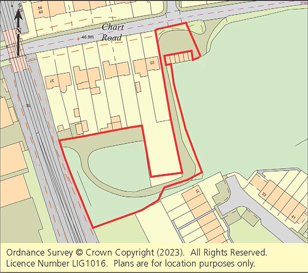
Land South Side & Adj 23 Chart Road, Ashford, Kent, TN23 3HT
An irregular parcel of land situated on the south side of Chart Road. The majority of the land is situated to the rear of numbers 27-37 (Odds). Access to the site is adjacent to a block of garages and number 23 Chart Road.
Site Measurements
The site extends to approximately 0.28 hectares (0.69 acres).
Local Planning Authority
Ashford Borough Council. Tel: 01233 331111. Website: ashford.gov.uk
Viewing
Viewing directly on site during daylight hours.
There is an addendum available to be read
in conjunction with the legal documentation.
Joint Agents
Skippers Esatae Agents
01233 632383
Important
All lots are sold subject to the Common Auction Conditions and Special Conditions of Sale (unless varied by the Sellers Solicitors), together with the Addendum, which will be available on Auction Day.
* Price Information
Guides are provided as an indication of each Seller’s minimum expectation. They are not necessarily figures at which a property will sell for and may change at any time prior to Auction. Unless stated otherwise, each Lot will be offered subject to a reserve (a figure below which the Auctioneer cannot sell the Lot during the Auction).
We expect the reserve will be set within the guide range or no more than 10% above a single figure guide. Please check our website regularly at cliveemson.co.uk, or contact us on 01622 608400, in order to stay fully informed with the up-to-date information.
Additional Fees
An Administration fee and Other non-optional fees may also be payable in addition to the bid price. All lots are offered subject to the Common Auction Conditions and Special Conditions of Sale or Revised Special Conditions of Sale (as applicable) and may include the repayment of search and other fees and or costs payable by the buyer.
All buyers are advised to inspect all available legal documentation prior to bidding and will be deemed to fully understand what they may be liable for if they are successful in purchasing. This should also include Stamp Duty, Land Registry fees and VAT which may become payable on completion in line with any property transaction, whether it is by auction or private treaty. If, as a buyer, you are in doubt you should seek advice from your own professional advisors. For more information on fees please go to Buyers Fees